
For sailors leaving the protected waters of North America’s Pacific Northwest, this is often the first offshore/overnight passage of a grand sailing adventure. And it can be a daunting one… even with tens of thousands of offshore miles under our keels, I’ll admit I suffered a few sleepless nights ahead of time.
Hence, my theory: This passage is like a band-aid; you just have to rip it off as quickly as possible!
Why does the WA/OR/Northern CA coast have a bad rep?
- Few ports of refuge – as conditions deteriorate out on the ocean, so do port river bar entrances, to the point where they are ‘Restricted’ (ie. deemed by USCG as too dangerous to navigate). Have you watched ‘Deadliest Catch: Dungeon Cove’ – filmed off the Oregon Coast? This trailer is perhaps a bit over dramatized, but you get the idea.
- Strong to gale force winds blowing every week or so, especially around ‘squash zones’ like Cape Mendocino in northern CA
- Fog – which means poor visibility (and makes you cold and wet)
- This combination of Wind and Fog, at the same time – ie, the wind does not necessarily blow the fog away, and the fog doesn’t necessarily soften the wind
- Marine traffic – container ships and fishing vessels
- Crab traps inshore – ready to wrap your propeller if motoring
- For sailors used to protected waters, it is often the first taste of a real ocean swell
Will has much more experience on this coast that I do, but as a ‘first timer’ I wanted to share my thoughts and tips.

KAIQUEST SAILING STATS – PORT ANGELES to SAN FRAN
- Total distance: Port Angeles to San Francisco: 760nm
- Leg 1: Port Angeles, WA, to Crescent City, CA – 475nm
- Departed PA @ 5:00am Aug 21, 2017, arrived CC @ 10:00am Aug 24, 2017 – 76 hrs
- Leg 2: Crescent City, CA, to San Francisco (Sausalito), CA – 285nm
- Departed CC @ 4:30pm Aug 26, arrived SF @ 3:00pm Aug 28 – 46.5 hrs
- Wind while sailing: Max 27 knots true, Average 15 knots true
- 40% Broad Reach
- 55% Wing on Wing
- 5% Spinnaker
- Motored with less than 8 knots true – out of Straight of Juan de Fuca, for 24 hours the first leg, and 24 hours the second leg
- Max swell: 2 meters with 1 meter wind waves
- Max speed (sailing): 7.5 knots consistent
- Min speed (sailing): 3.5 knots
Getting out the Straight of Juan de Fuca
This is the first challenge. Unless you get extremely lucky with an outflow wind, it’s recommended to wait for little wind and an ebb tide. You really want to avoid wind on current in these waters.
We left Port Angeles at 5am and motored at up to 10 knots on a strong ebb. We were rounding Cape Flattery as the tide turned, just after noon.
We were lucky to have a good weather window to continue south, otherwise we certainly would have pulled into Neah Bay.
How far offshore?
There are two schools of thought. Some choose to sail out 120 or even 150 nm and then head south, possibly to find a more consistent swell pattern away from the continental shelf? Or possibly this tactic pre-dates today’s more reliable weather forecasting?
We struggle to understand this ‘go way offshore’ tactic for a number of reasons:
a) Why add so many more miles?
b) There may be less fog way offshore, but you’ll likely still experience fog on the way out and way in.
c) It is difficult to find a consistently good 5-6-7 day weather window on this coast, so you run the risk of seeing nasty conditions on the way back inshore.
d) As a first offshore passage for many, why not make it as short and least traumatizing as possible?
e) You are now cruising – don’t you want to see some of the sites of this rugged coast along the way? I did!
We see no reason to sail further than 35-40 nm offshore. Round Cape Flattery, and head the direction you want to go – south, not west. You will be inshore of major shipping lanes, and offshore of crab pots.
PASSAGE PLANNING & STOPS
In our experience, forecasting up to three days out is generally pretty accurate, but is less reliable after that. It’s quite easy find a three day weather window (favorable wind AND sea state) to sail south to Newport (Yaquina Bay), OR, Coos Bay, OR, or Crescent City, CA.
Our mentality was to keep going if conditions looked okay to round Cape Mendicino as we approached it. But, we soon saw a forecast of up to 40 knots and disturbing seas, so we were glad to pull in to Crescent City and wait for a more favorable window for Leg 2.
Although we could have stopped anywhere (again, we left when the swell forecast was not huge so bar crossings would not have been a problem), we were aiming for Crescent City as it is NOT a bar crossing, and navigable in any conditions. It’s also further south and close to the famous Redwood forests!
A piece of advice for those new to offshore: Make things easy on yourself – choose a forecast with lighter winds. We know newbies who say “I can’t wait to be sailing out there, and I’d prefer 30 knots of wind to motoring”. Good luck to you! I’m sure you wife agrees?! Also remember that grib files show an average, so if 30 knots is forecast, you’re probably going to see gusts in the high 30’s and very uncomfortable seas.

Receiving weather OFFSHORE
We followed Passage Weather prior to departure (review both wind and swell). Start watching a few months prior to understand the patterns.
While out there we found the NOAA zone forecasts very accurate (but always add 5 knots to stronger forecasts!) We weren’t quite close enough to hear the forecasts announced clearly over the VHF.
I downloaded the NOAA text forecasts daily via Iridium satellite phone and my mailasail email on the ipad:
Email to: query@saildocs.com
Subject: irrelevant
Body: (choose your zones – each text file will come back as a seperate email, approx 5kb each)
send pzz170
send pzz173
etc.
I couldn’t find a clear overview of the zones online for the WA/OR & CA Coast, so I made one and printed it out for the passage. Download my NOAA FORECAST ZONES Cheat Sheet
Bear in mind there is also a ‘further offshore’ zone (60nm to 120nm…. if you need it)
Fog
The fog is what makes this passage unpleasant at times… zero visibility, damp and wet, and cold! There’s nothing you can do except grin and bear it. Maybe embrace it…?… since you know your night watches will soon be spent in shorts and a t-shirt!
We found ourselves for many hours (on both legs) in conditions of dense fog combined with moderate winds (20+ knots apparent). It’s an odd feeling as you plow along into the unknown.
It is easy to stay perfectly safe and confident with the proper gear and instrumentation. If you have a full or partial enclosure, be prepared for even less visibility as condensation forms on the window panels – we couldn’t see the bow of the boat! But at least you stay warmer.
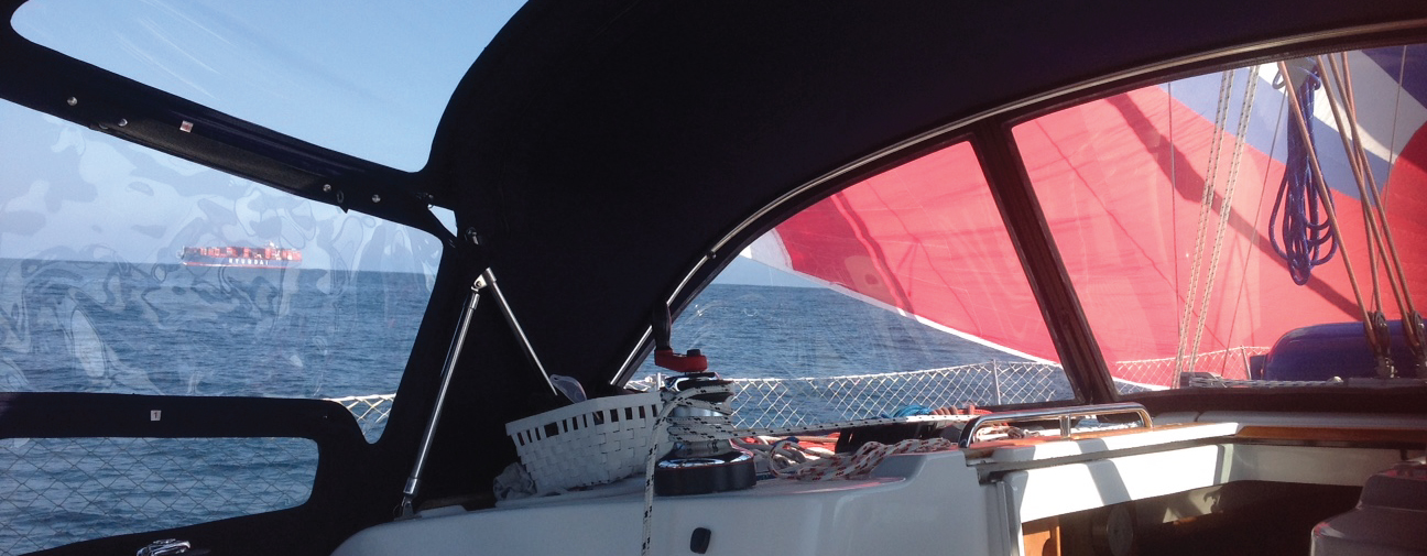
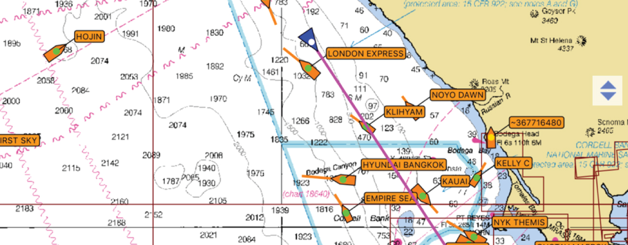
Marine Traffic
All freighters/tankers/large towing vessels transmit an AIS signal.
However, most fishing boats do not. This was a big shock to us!
Plan to keep the radar on through the night. We made the initial mistake of having our radar on a 12 nm range – which is just too high to see the small, close blips. We soon found that a 6 nm range was ideal. Often the fishing boats do not show up on radar until you are within 2-3nm of them. We’re pretty sure they toy with sailboats… coming straight at you and then diverting course. Don’t expect an answer on the VHF.
It seemed to us that at 35 nm offshore, we were still well inboard of the major shipping lanes. We saw very few freighters.
To give you an idea of the traffic out there:
Leg 1 (Port Angeles, WA, to Crescent City, CA):
- Day/Night 1 – About 10 boats on the first night out (fishing boats and one research vessel).
- Day/Night 2 – 25nm offshore of the Columbia River, we saw one incoming freighter that was nowhere near us, but he still diverted course for us to be sure. The second night (a clear one), we tracked fishing boats in the inshore distance on radar and visually.
- Day/Night 3 – few boats
Leg 2 (Crescent City, CA, to San Francisco, CA):
- Night 1 – We were only 18 nm offshore at the most on this leg. We saw a couple of fishing boats.
- Night 2/Morning – Early morning as we approached San Francisco, there were A LOT of AIS targets – all freighters or tugs. The big guys stick to the shipping lanes so it is easy to stay out of their way.
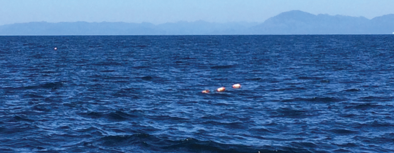
Crab POTS
There are crab traps inshore. A reliable ex-US Coast Guard Ship Captain told us that so long as you are in more than 500 feet of water, you won’t see any traps. Spot on!
If you sail outboard of the continental shelf (where depths drop off into oblivion at 5-15nm offshore, depending where you are), there are no traps to worry about. You just want to make sure you are heading out and coming back in during light hours.
Wildlife
I’m not the only one who saw a shark! Seems to be fairly common.
There were many whale sightings reported as well. We saw the highest concentration of whales as we rounded Cape Flattery and then again on the approach to San Francisco.
San Francisco Marine Traffic Control makes a regular broadcast of whale activity in the area. It was announced to be highest near the Farallon Islands and Cordell Bank. And lo and behold, as we sailed closer to the bank early morning, we found ourselves surrounded by a pod of 25 – 30 humpbacks! Quite the wake up!
Those who fish, catch fish.
Top 5 Most Important Gear for this PASSAGE
- Radar – because most fishing vessels don’t have AIS
- AIS Transceiver (ability to receive AND transmit) – A Class B Transceiver should be mandatory for all cruising boats
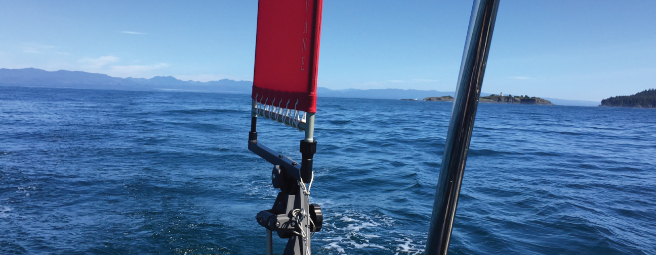
- Windvane – a more comfortable ride, and the power draw of running radar and an autopilot would be way too much.
- Engine – counting on it to get in and out of port, and make time when there is no wind. Another point – Make time! – don’t bob around out there as bad weather is usually coming.
- Easy pole set-up – goes for downwind sailing anywhere, and it is key. You will always need a pole on the genoa, with foreguy and aft guy to keep it rigidly in place. Because you may have to jibe the pole a few times, you need a flawless set up for doing so. If unsure about this procedure, practice it a lot before you go. Requires one person on deck, the other manning lines.
More Tips
- Get a super absorbent shammy (we recommend ‘the Absorber’) – part of your nighttime watch duties will be to mop up the condensation on the inside and outside of the window panels. This is a must have!!
- Bring a sleeping bag – we had to buy one in Crescent City. It can be very cold and damp in the cockpit.
- Make sure you have headlamps with ‘red’ light – best for not blinding others or yourself at night
- Pre make hearty meals (soups, stews) for first couple nights over. We liked served over blanched brocolli or kale – so easy!
- Keep plain salted crackers handy at all times
- Stay hydrated. Have multiple water bottles in the fridge. Sometimes filling up the water bottle feels like a lot of work, especially in the middle of the night.
LOWLIGHTS
Will: “The first night out. The darkness and fog socked us in…”
Sarah: Definitely the first night. It started off well and then we were suddenly sailing in rough conditions with absolutely zero visibility. I felt green (unlike me).
HIGHLIGHTS
Will: “Sailing under the Golden Gate after a stressful morning weaving between humpbacks and ships.”
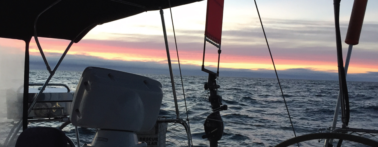
Sarah: The beautiful sunsets at sea! Also the stop in Crescent City – dinner on shore at the Chart Room, watching the sealions play and visiting the Redwood forests. Oh, and sailing under the GGB of course!

SUMMARY
While we did have really special times out there, sailing this coast is very different from offshore sailing in the tropics (which we both much prefer, ha!) If you’re not having a ton of fun, just remember that it only gets better from here…
These are just our musings and experiences (yours may be very different). I enjoyed our tactic, called ‘minimizing the discomfort’, and all in all, we couldn’t have planned a better passage south.

Wow that’s a blog! Great info x
LikeLike
Haha, yup, a bit of a lengthy one! Thought I should write out ALL of the details while still ‘fresh’ in my mind. This is the type of info I was searching for before we set off. xoxox
LikeLike
Quite the journey!
Hope you’ve been able to sit back and relax in SF before the show. Keep the posts coming xox
LikeLike
EXCELLENT POST!
LikeLike
Love your post!! Good information. Next fall we hope to go south.
Karen and Fred
S/V Limelight.
LikeLike
Exciting that you’ll be heading south as well! Hopefully our bows will cross one day 🙂
LikeLike